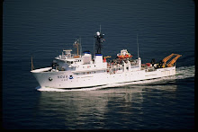
Wednesday, January 13, 2010

Bronc Buoy Day! By 8 this morning ship time we were running out the Nielspin and slapping on the fairings from the recovery yesterday.Some of these were pretty clean, but the majority of them, the ones that the teachers got to help with were pretty slimy and even

had barnacles stuck to them.The fairings are added to help the reduce shake on the wire that can be produced by currents close to the equator.


We put these airfoil shaped fairings on the first 250 meters, after that it was smooth sailing. Because the Bronc-Bobcat buoy at 0: 155W is a TAO-CO2 buoy it needed a little extra


weight on the anchor, 6200 pounds of steel.


Once the anchor was off the fantail and sinking we noticed that there was a ship close to the location of the buoy. The science crew commented that this must be a new record for the fishermen finding one of the buoys. It seems that fishermen love the TAO buoys since they attract fish. One of the scientists said, “A buoy for these guys is like having your own private fishing hole”. It will be interesting to see if this ship leaves, or just steams away and waits for us to be clear of the area and then comes back.


Around 12:15 today, actually Rick and Art were just finishing up lunch when the call came from Survey, “Teacher’s at Sea report to the CTD deck”. The first order of business was to lower an Argo buoy over the side of the ship and then to release the buoy using a quick release.According the home page for Argo


(http://www.argo.ucsd.edu/), Argo is a global array of 3,000 (3199 on Jan 13) free-drifting profiling floats that measure the temperature and salinity of the upper 2000 m of the ocean.


These buoys are unique because the sink to between 1000 and 2000 meters and then on regular intervals, generally 10 days the Argo returns to the surface to transmit and the data it has collected. This allows, for the first time, continuous monitoring of the temperature, salinity, and velocity of the upper ocean, with all data being relayed and made publicly available within hours after collection.


Once the Argo was on its own a call was made to the bridge for the crew to help with the deployment of the Bronc Buoy. This AOML drifter’s data will be available in a few days from the Adopt-A-Drifter website. It will be interesting to follow the Bronc Buoy and see where it goes over the next several years.


Our afternoon will be spent sailing south, in the Southern Hemisphere for the first time this trip and devoted to teardown of the old 0: 155W buoy and set-up of our next buoy.


After the deployment of the new CO2 buoy we crossed the equator and entered the southern hemisphere. Our new position put us in the southern hemisphere and we officially went from the winter to the summer season. Currently (at 6:15 pm MST) we are approximately 28.5 miles (at 6:19 MST) miles south of the equator.


Those of you in Montana today experienced temperatures ranging from 30 to 40 degrees while the temperatures around the equator (regardless of north - winter or south- summer) are staying at about 84 degrees Fahrenheit. Quite a warm temperature when considering the area north of the equator is technically in the Winter season. Regardless, of your position just north or south of the equator, the deck work required to recover and deploy TAO buoys is demanding. An air temperature of 84 degrees seems mild but is really very hot when working on a deck that is painted dark gray. Everyone has to be careful to make sure they drink enough water to stay hydrated. This operation is certainly a team effort. Everyone works together to make sure the job gets done by checking to make sure those participating in deployments or recoveries are safe. This means checking for life jackets, hardhats, application of sunscreen, the need for water etc. Higher education could take a lesson from the way that this crew collaborates and works together!


Tuesday, January 12, 2010

We are almost there! We are holding station at 0 degrees 3 minutes North and 154 degrees 58 minutes West while we conduct out second deep (3000 meter) CTD. This cast began at 9:13 AM ship time (19:13 Zulu) and made it to depth at 10:10 AM ship time. The depth is 4650 meters at this location.


This cast has significance to Rick’s students (and his Daughter) because this is the first cup cast the cruise.

Rick spent about 30 minutes making sure that the mesh bags with 172 cups (a record for a single cast on the KA) and the bag with the Styrofoam head were attached on the instrument cage securely and in a way that would not interfere with the operation of the instruments on the CTD. As you can see from these pictures the results were profound.


When Rick returns to the classroom he will return all the cups to their rightful owners. The kids will then recalculate the volume, mass, height and diameter (if they can) and determine the rate of compression for the styrofoam cups. And of course the famous shrunken head his Daughter provided.


After recovery of the CTD Rick and Art spent about a 45 minutes getting the mesh bags off the CTD, untied and for a few of the cups that had nested, carefully pulling them apart so that they would dry as individual “mini-cups”. As soon as this task was completed we moved to the TAO-CO2 Buoy that we are going to replace. The new buoy will be the Bobcat-Bronc Buoy and will be deployed tomorrow since the recovery started around 2 PM and wasn’t complete until just about dark. Tonight we will remaining on station through the night, making five mile loops around the position of the new buoy so there is a very good chance that we will cross the equator 10 or more times tonight.


As Rick wrote, today we recovered a buoy designed to measure the amount of CO2 in ocean water in addition to typical data (i.e., temperature, wind speed, humidity, rain and salinity). During the recovery I had the opportunity to ride the RHIB out to the CO2buoy to help the Chief Scientist remove some equipment before pulling the buoy onto the ship. Our ride to the buoy was phenomenal! We were told by the Coxswain to “hold on tight” to the ropes surrounding the top of the RHIB. As we pushed through the indigo waves of the ocean at


the equator, I felt like a Montana bull rider holding on for dear life. While Brian was removing the anemometer and the rain gauge, I attached a short rope with a coupling to one leg of the buoy that a larger rope could be attached and bring the buoy aboard the ship. While on the buoy, I realized that the only other thing in site for miles was our mother ship, the Ka’Imimoana!


The RHIB returned to pick us up and then went back to the ship to retrieve the rope that would be attached to the buoy. After some concern that the anchor did not release, the buoy was hauled aboard and stowed for future use. Tomorrow the new CO2 buoy will be deployed.


This morning we were at 3 minutes North (3 nautical miles) of the equator, about a half hour ago we were only 3/10th of a mile North, we are really getting close. On to the Southern Hemisphere!

Art and Rick

Monday, January 11, 2010

Today was our opportunity to take it a little easier as compared to yesterday’s long day of buoy recovery and deployment that did not end until after dark. We had an opportunity to catch-up on some email and work on an article that is due on the 15th of January. Nothing like being under a time crunch to get you motivated. The day is filled with sun and winds are "fresh" as it is called by some.

The first order of business was to help with the 3N: 155W shallow cast CTD. It is still had to grasp that shallow is over 3000 feet down into the ocean. When the pressure of the water increases the equivalent of 1 atmosphere each 10 meters that is a lot of pressure when something goes down 1000 meters like the shallow CTD does. When we make our deep cast (3000 meters) at the equator the pressure on the instruments is staggering. What would it be in pounds per square inch?

Once the CTD was back on the ship and we resumed our course south along the 155W longitude line we worked on getting the Atlantic Oceanographic and Meteorological Laboratory (AOML) drifter prepared for its deployment as the Bronc Buoy at the Equator along the 155W line.
If followers look back to a post from October they can see the stickers that the students at Billings Senior High Freshman Academy prepared for the drifter they were adopting through NOAA’s Adopt-A-Drifter Program. If you are interested in adopting a drifter you can find information about the program in the “links to learning a little more” area of this Blog.


After lunch we helped the Brian, Jim and Alan to put together a specialized TAO buoy that collects information about the amount of dissolved Carbon Dioxide in the ocean in addition to the typical temperature, salinity, humidity and rain data that is gathered. These buoys appear to be easy to build.


However, standing on top of a TAO buoy anchored to the ship’s deck while trying to hold on with one hand and attach electronic sensors with the other can be daunting as the ship pitches to and fro considering the seas we had today.

One gains a whole new perspective and respect for the power of the Ocean and the scientists who routinely build these buoys so that good data can be collected to help mankind.


One added benefit of working on the buoys is that occasionally we have the chance to do a little personalizing. Art painted MSU CATS on one side since he works at MSU and since I just graduated from Bozeman last May. On the other side Rick put in a plug for Billings Senior Broncs. So now the Broncs and the Cats will be part of the TAO array at 155W at the equator for the next year.


We also had our first fresh sashimi and poke. Rick for one can’t wait! It is great that we have a crew with diverse skills and hobbies. Deck crew who prepare top notch sashimi and a doc who makes poke with his help.


On to the Equator and a first crossing for Art!


"Science isn't pretty..." Dexter from the cartoon Dexter's Laboratory tells his sister. What he really needs to say is that science is hard work, work that takes a team of scientists, technical specialists, and in this case the dedicated crew from the NOAA ship Ka'Imimoana. Yesterday was our first real taste of what it takes to get the data needed to understand the role of the tropical ocean in modifying the world's

climate. We began out day with a shallow cast of the CTD at 6N:155W that ended around 7AM. A shallow cast still goes to a depth of 1000 meters (how many feet is that?) and takes about two to three hours to complete. The Survey Technician, a couple of the deck crew and several officers worked though heavy winds (35knots) and seas of around 18 feet and intermittent downpours of rain to make the data from the TAO Buoy array more solid. Once the CTD was back on the ship and secured we headed toward our first recovery/deploy at 5N:155W.


Our next task was to recover a TAO buoy that had been sending climate data for the past 8 months. The recovery began with a pass by the buoy to make sure that everything was still attached and that the buoy would be safe to "hop" and then come aboard. During these “fly-bys” or passes to view the condition of the old buoy the crew had an opportunity to fish. The Doc caught a nice Mahi Mahi as you can see in the image. Two Ahi (Yellow fin tuna…fresh poke and sashimi…yum) were caught, a Wahoo or Ono, and a small Galapagos shark that was released back in to the ocean.


After our successful fishing the RHIB was sent over to the buoy to secure the ‘bird’ (how we refer to the anemometer) and attach a line for hauling in the buoy to the ship. Once the winch line is attached the RHIB was brought back onboard and we started the recovery. Retrieving the buoy produced a steady rhythm of line in, filling spools, and switching to empty spools. Even the Ensign’s got in on the deck action running in a spool and scraping the barnacles off the old buoy.


Once the buoy was completely recovered (about 4 hours) we set the deck for deployment of the new buoy and broke for dinner. After dinner we began the deployment which took about 3 hours and ended in the dark around 8PM. Deployment of buoys is basically the opposite of the recovery process: Nielspin, plastic coated steel cable, with its sensors attached are then attached to the buoy with its electronics.


This line along with thousands of meters of braided line feed out into the water until the buoy’s anchor position is reached. Once the buoy was anchored in the water we waited for about a half an hour then swung by the buoy to check that it was operational. Once the buoy was confirmed as successful, the crew began to prepare for the 5N CTD and our first drifter buoy deployment.


Rick helped with this CTD to continue his training for his solo CTD’s coming in a day or so. The 5N CTD, like the 6N was a shallow cast and took about 2 hours and once the CTD was stowed Rick, the Survey Technician and two Ensign’s bid farewell to the first drifter and the day was pau (“done”) as the Hawaiians say. Art and Rick

Saturday, January 9, 2010

Today was a busy day. We were up before dawn so we could check on an existing buoy close to the location of our new deployment. We made what was called a 'fly-by'. The ship closed on the buoy and at about a mile it was vaguely visible in the early dawn.

The first buoy deployment of our mission began about 7:30 AM and we had the anchor in the water about 11AM and everything went smooth. The new generation TAO buoy was deployed at 155 W longitude and 8 N latitude in a depth of 5200 meters (about 3.2 miles deep!). The TAO buoys, also called moorings, are anchored to the ocean floor using plastic coated steel cable and heavy rope. We have a drawing of the standard buoy to give you some idea what the whole package looks like, at the surface as well as below. The adjacent image is of the actual buoy that we deployed today. As you can see the color scheme has change to a solid International Yellow above the waterline.


During the initial deployment electronic sensors are placed at specific depths on a special coated steal wire. These sensors are designed to by induction and send information about conductivity (salinity), temperature and sometimes depth to the instrument tube in the buoy.This image shows two of the science team placing one of these sensors on the line.


The information provided by these sensors, and those on the buoy that measure surface conditions, help climate scientists better model the behavior of the ocean atmosphere interface and understand what patterns are more representative of El Nino, La Nina, or Neutral conditions.


In addition to the deploy of this first buoy on our trip, the ship was also engaged in the deployment and recovery of the first deep CTD. This 3000-meter (about 9750 feet or slightly over 1 3/4th miles down) cast went fairly smoothly until it was on its way back to the surface. The winch
controller overheated and the CTD had to rest
for about one hour while the instrument package


sat at 2000 meters. After the control circuits had a chance to cool we were able to continue the recovery of the CTD and resume or course south on the 155 W to our next station at 7N for a 1000 meter CTD cast. There is a good chance that we will do the CTD later this evening since it will take about six hours for the ship to transit one degree depending on sea conditions.

Rick and Art

Friday, January 8, 2010

Today was another day of transit for the KA. We did work on the buoy that will be deployed, like making connections between the buoy and the anchor line and are running the electronics check one more time prior to the actual drop off the ship. Rick was also scheduled to observe and get checked out on the deployment, monitoring of the programs, recovery of the CTD so he is ready


to do them with the deck department on the half-degree casts that begin at 2.5 degrees North and run every half-degree to the 2.5 South. The initial run-through was scheduled for 10 AM, but due to the heavy seas, some other items had to be taken care of at that time and the CTD was rescheduled for 2 PM. At 2 the engineers discovered that a fan needed to run the winch electronics was malfunctioning and so we were delayed until 4 PM. Well, as we began to take-up the slack in the CTD line the winch, actually a 10,000 capacity “J-Frame” gave some problems and so the CTD is stowed until the engineers can make the repairs needed to make the cast. Rick is hopeful that the CTD winch will be repaired soon so he can shrink the cups and the head.


While Rick was waiting for the winch to be fixed he read an email from a fourth grade class in Billings asking about pollution in the ocean and what is done to prevent pollution from getting in the ocean from the ship. I asked one of the NOAA Officers what the KA did to reduce pollution and he shared that beyond the necessary practice of removing all plastic from ship waste, the crew of the KA has a recycling program that keeps aluminum cans and recyclable plastic soda bottles out of the “overboard disposal”. The ship also


separates contaminated paper products from clean paper. For this ship, very little is sent to “Davy Jones”, in other words goes over the side. Food waste and some biodegradable paper products are about all that go into the ocean, and only at distances approved by international treaty. The recycling and the materials that are unwelcome in the ocean are bagged and remain on the KA until the crew can recycle and the port can handle the waste.

Just before going to the Mess for dinner I noticed the Ensigns’ working on the charts. It looked to me like they were measuring and checking on test questions, but they we actually updating and correcting the charts so that they could still be used for navigation. Speaking of dinner, tonight we had, well I had steak and lobster, fresh bread, and iced tea. Other options included chicken stir-fry, an vegetarian dish, corn on the cob, mash potatoes and gravy, a great salad bar, and of course several types of dessert.

Rick

Thursday, January 7, 2010

A wee bit rocky today. We have a swell that seems to be coming from the starboard (right) aft quarter, which gives the ship a strange movement that has made some of the folks a little queasy. Ships tend to roll (movement around an imaginary line running bow to stern) pitch (movement up and down around an imaginary line running 90 degrees to the direction of roll) and yaw (movement left or right of the imaginary line running bow to stern). Today the KA is doing all three at the same time which is why we are encouraged to take Meclizine HCL (Dramamine) for a few days prior to the trip and for the first few days at sea. Taking this makes it easier for the crew to function in an environment that has un-natural motion without getting ‘seasick’. Even with the weird motion of the ship, we still have work to do and for us “newbies” things to learn before we are allowed to do them,
like learn how to set the ‘painter line’ for the RHIB so that we will stay attached to the ship in the advent that the engine of the RIHB doesn’t start or other various bad things that can happen to a little boat in a big ocean. We didn’t actually ride in the RHIB today, we simply learned how to enter the boat, where to sit , where the emergency items are located, and how to start and steer the boat.


One of the tasks that needs to be done prior to the deployment of our first Buoy at 8N:155W is to determine (as close as possible) the ideal position for the buoy’s anchor. To do this it is essential to know the true depth of the ocean and the topography (collectively called bathymetry) of the area within a few miles of the target latitude and longitude for the buoy. Brian, our Chief Scientist, will determine the depth and location for the anchor by using both satellite sea surface heights and actual sonar depth data from ships that have been in the area. In reality, there really isn’t much

hard data, physical sonar tracks, for much of the ocean and much of the depth is determined by the actually height of the sea surface as measured by satellite. These measurements take into account variables, such as orbit of the satellite, atmospheric effects on radar, and tides and compare the computer result to a mathematical ellipsoid model of the Earth’s shape. Sounds pretty complicated, and it is, but we can use this calculated sea surface to help determine the depth of the ocean since the surface mirrors the actual topography of the ocean floor. For Academy students, you will have the opportunity to do two activities from the American Meteorological Society (AMS) that will help you understand what it is that we are attempting to do.


For the fishermen out there, we caught our first fish this cruise. A Wahoo (Hawaiian's call this fish Ono which means "good" because it is a good fish to eat. Some of the crew have been putting out troll lines off the fantail of the ship with the hope that some hungry fish might see the lure as a treat they are unable to resist. I guess we don't have to go home skunked now.


One last comment from Rick, my school has a set of four computer monitors in the hall outside of my classroom thanks to Mr. Beals. The Earth Science department puts up content relevant sites for the kids to see as they pass from room to room. Typically we would have the weather (which I hear has been bitter) some current earthquake data from our own seismograph and other content sites that relate to the current teaching units. Thank you Senior High Academy for giving me the opportunity to be on the screen in the hall.

Rick