Tuesday, January 19, 2010

Safety Drills and an island on the horizon were the highlights of the day. Today we had quite the rainstorm, it came in gray sheets that pounded the deck and boiled the sea surface, like we were running the ship through a car wash back home..We also had gusts that cooled the air for
the first time in several days. It was pleasant while it lasted but when the sun came out the air was steamy.


Safety is a big issue on a ship. We have regular weekly drills including Man Overboard, Abandon Ship and Fire Drills.


In addition, today after lunch we participated in what is called a safety stand down where we observed several safety demos including using a line gun. You can see Art prepping the gun under the watchful eye of Chris the Chief Bosun and Rick firing the gun. The line gun uses 3000 psi of air pressure to shoot a small rocket with a line out to 750 feet. This tool is used when it is necessary to get a line to another ship or land facility when the ship can’t be close enough for a safe hand toss. After our time on the firing line we learned about fixing ruptured or leaking pipes and how to shore up a sagging upper deck with telescopic metal vertical braces.

When a safety drill is called, a general alarm bell (see picture) is rung notifying all of the ships’ crew, scientists and others to muster (or go) to their assigned stations. The stations are different positions on the ship such as the buoy deck (man

overboard station), the top deck by the RHIB
(abandon ship) and the mess – cafeteria (fire). The positions in parentheses are my stations for

this cruise – they differ for other participants. When practicing the drill for abandon ship, we are shown where the inflatable life boats (see pictures for life boats) are stored and to know to bring as much water as possible from the water locker.


We have begun a series of video interviews of the different NOAA corps crew. We began yesterday

with the three new Ensigns. Today we interviewed the oiler, Mike Robinson and the Lieutenant Commander Helen “Doc” Ballantyne (Ship’s Nurse/PA ). Our tour of the engine room was fascinating in addition to being very noisy and very warm. This area can really be considered the heart of the ship. The diesel engines, generators, propulsion mechanism, sewage disposal system, and filters for producing fresh water are all located here.

Lt.Cmdr. Ballantyne or “Doc” is not only a nurse who takes care of sick crew members but is also responsible for procedures for handling and storing hazardous materials, disaster care, and other safety related issues. NOAA is always looking for good nurse practitioners, so if you want adventure on the high seas, give NOAA a call!


As we were on deck for the man overboard we passed Nassau a small island in the Cook Islands located close to 11 degrees 40 minutes South and 165 degrees 24 minutes West. Another day of sailing and we should be close enough to see the Samoan Islands.

Until tomorrow, Rick and Art.


Monday, January 18, 2010

Painting in the morning, painting in the afternoon. We had a time change this morning, we set our clocks back (retarded) them one hour so we are now four hours earlier than Montana or 11 hours earlier than GMT (Greenwich Mean
Time) or Zulu. This means that we are almost half way around the world from the Prime Meridian that runs through Greenwich England.
You might notice that it looks like Rick is in a fog, well he is. The difference between the inside of the ship and the outside of the ship in regards


to temperature and humidity is huge. The ship is generally around 21 degrees c or close to 70 degrees F with low humidity and outside has been close to 31 degrees c or about 87 degrees F with high humidity. When you bring something like a camera outside from the cooler interior of the ship the moisture in the humid outside air condenses on the camera and instant fog.


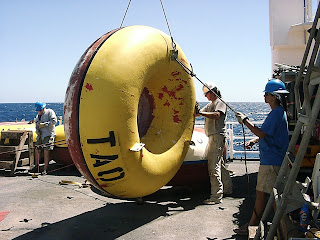
We painted the international yellow on the top half of the four tolroids and now all the buoys will be the new color scheme, no more orange and white top half’s anymore.

You may have noticed that the sky is gray and the sea is fairly calm. We are in the Doldrums, an area of low pressure and often very little wind. This area is also known as the "Horse Latitudes". Do you know why?

While we were waiting for the paint to dry we watched Alen refresh the sonic releases that connect the anchor to the nylon anchor line.
Each of these releases costs about $12,000 and it is essential to use them over and over so replacing the battery, the rubber “O” rings and
filling them with argon is a must after they are


recovered with the anchor line Nilspin and nylon, pretty much ever thing that can be re-used is reused in order to minimize the cost of the project. Because we are able to use the acoustical releases only the iron anchor and some chain are left on the bottom of the ocean where they rust away eventually. It is hard to see but just before the releases are approved for re-deployment Argon is put into the body of the refreshed unit to provide and inert environment for the electronics. By removing the air, the risk of oxidation to the components is reduced.


After lunch the paint was dry enough that we taped in prep for painting the black waterline and we put the TAO on the donuts. Now these are ready for deployment on the next two legs of the cruise. We also had some time today to interview some of the crew on the KA. Today we chatted with three of the four young Ensign's who are stationed on this ship. We asked them a variety of questions about life in NOAA and the types of degrees that they have and their interests. We discovered that one of the Ensign Rose (white shirt) is from Wyoming and that Rick went to school with one of her uncles and that she is distantly related to his wife through a cousin. Weird how small the world really is.


Two days ago, on 1/16/10, we conducted the last deep CTD at about 3,000 meters (about 2 miles). Rick had about 130 cups to send down and Art ran an experiment with control for Rossiter School in Helena. Just to review, this operation sends down a large, round instrument with tubes that collect water samples at different depths up


to 3,000 meters. The intent of this procedure is to measure the salinity, Temperature and Pressure at different depths of the Ocean. As the depth of the ocean increases, so does the


pressure of the water. An experiment that we can do to see the strength of the pressure is to attach a bag of Styrofoam cups to the CTD instrument. As the instrument sinks, what do you think would happen to the Styrofoam cups? Look at the picture of the cups before being sunk into the ocean depths and after. How would you describe the pressure of the ocean waters at 3,000 meters?

Art and Rick

Sunday, January 17, 2010

Today was not all that physically demanding which is good since it was 30.5 degrees Celsius by 9:30 AM ship time. My students should be able to figure out the temperature in temperature units they are more familiar with.While it was still fairly cool this morning Art and Rick helped Alen paint the anti fouling paint on the bottom of each of the three tolroids

that needed it. Once the deck crew flipped them back to top side up, Alen discovered that one of the buoys had been hit and was cracked and so he needed to do some grinding and patching before painting the yellow. So we are going to finish the paint job early tomorrow after the patch has time to cure.


Land Ho! Later in the day we sighted land for the first time since we lost sight on Hawaii on the 6th. We came upon Tautua Island, which is part of the Cook Islands. If you take a look on Google Earth around 9 degrees: 13 minutes South and 157 degrees: 58 minutes West you can see the


island and the village on the island. We weren’t very close, so we couldn’t actually see the village, but it was nice to see land after 10 days of the vast expanse of the Pacific in every direction to the horizon.

Art and Rick


Saturday, January 16, 2010

Today was a day of odds and ends. We had planned to paint first thing after breakfast and Art and Rick got started masking off the water line on one of the orange and white buoys that needs to be painted. This one was chosen to do first because it only needed a coat of yellow and not a complete repaint. The other three buoy floats need the rust colored anti-fouling paint

and the yellow. Just about the time we got the tape on, it was determined that all the buoys
would have the anti- fouling paint first so we had to wait while the tolroids or “donuts” were

flipped. In the process of turning them we discovered that a couple of the buoys were partially full of water and Alen had to drill them out to allow the water to pour out. While these were draining and drying we were put on hold for painting until tomorrow. Alen had to carefully look over the donuts and fix any cracks in the fiberglass hull and reseal the mounting brackets where they pass through the hull.

Since painting was sidetracked for a day, we got to participate in one of the necessary, but less exciting aspects of scientific research…inventory. As we mentioned yesterday, science is hard work and hopping a buoy or working on the fantail doing fairings with the ocean breaking over the deck has an element of risk and can be exciting. In order to do the exciting parts of the
research safely and efficiently means that you have to have the right equipment and the right number of parts to make the instruments work and the science happen.


So today we counted bolts, and paintbrushes, screwdrivers, nylon zip ties and even pencils and post-it notes, everything that allows us to do the science. Today was a reminder that even the most exciting job in the world, like climbing up a swaying mast on a ship, might have to be done because you need to get the serial number off an antenna, an antenna that allows you to communicate the fruit of your research back to those who can use it to understand the world’s climate a little better.


About 4:30 pm today we approached a TAO buoy that needed to be visually checked for any damage. Prior to this check, the ship makes several close passes to the buoy for examinination and more importantly so the crew can fish! Six long lines were in the water as we past the buoy on four separate occasions. No one caught any fish. However, Alen speculated that this was because the buoy had been deployed fairly recently and there was not enough time for it to form a food chain of small microorganisms that eventually attract top level carnivores like Ono, Tuna and Mahi Mahi. Bummer!


The last order of business today was to deploy the last deep (3000 meter) CTD at 8 South on the 155 West Longitude line. Rick sent the remainder of the Styrofoam cups from his school, cups for Art’s wife’s school in Helena (Rossiter Elementary) and a couple for his grand kids plus two extras he had for the Ensigns down in mesh bags attached to the instrument.

Soon we say farewell to the 155 West line as we make our way toward Apia, Samoa and the end of our experiences aboard the Ka'Imimoana.

Rick and Art

Friday, January 15, 2010

Bronc Buoy is Active

Hi Everyone,
I was just notified that Bronc Buoy is up and running on the NOAA Adopt a Drifter tracking page (http://www.adp.noaa.gov/track_drifting_buoys.html), which is part of the Adopt a Drifter website (www.adp.noaa.gov). Just a few sea surface temperature (SST) values are displayed for Bronc Buoy thus far, which makes it very difficult to see on the tracking maps. But, there is a table of SST measurements on the tracking page and you can begin by manually plotting the data point(s) on a map or chart of the Pacific.

Directions:
Once on the tracking page, scroll down to your schools (Billings Senior Freshman Academy is first). Click the circle next to your buoy number (90404) and World Meteorological Organization's (WMO) ID # for your buoy. Scroll down the page to the next set of selection boxes where you can click next to "Map showing measurements", "Map showing drifter track dates", or "Table of measurements". The Table of measurements option for SST might be the best choice right now until there are more data points. Once you've chosen an option, then click on "View Results!" and wait a few seconds while the map or data are displayed. Note: Bronc Buoy does not measure Sea Level Pressure so this is not a possible option.

If you get confused by these instructions simply click on the track drifting buoy link on the right side of the blog, then click the teachers link, then the track a drifter link and there we are.

Rick
We have our last buoy of the 155 West line in the water and the anchor is set. Today began with a ride for Rick over the old buoy where he was responsible for removing an old loop of rope in order to put on the shackle and line that the tow line would be attached to.


You would think that cutting a three-eights nylon line would be pretty easy, and you would be right if that line wasn’t attached to a rocking, slime covered buoy floating in the middle of an ocean that is over 5000 meters deep.

It would also have helped if my knock-off Leatherman had a sharper blade.Anyway, Al and I went out the buoy on the RHIB and got a pretty good spray here and there as you can see from the water drops on some of the images.

Once we were on the buoy Al removed the ‘Bird” and handed to the support crew in the RHIB. If it weren’t for these men and women we (the scientists) would not be able to collect the data. This is science on the front lines and it takes a dedicated and well-trained crew to make the endeavor of science one that produces meaningful, valid, and important data.


Once the ‘Bird’ is off the buoy and the towline is attached it is time to go back to the KA to pick-up the towline so that the buoy can be recovered and the next phase of the process can begin, deployment of the new buoy that will replace this one.


During the recovery Art and Rick often work as a team spooling the nylon because it takes two people to re-spool the line in a way to prevent tangles, one person to provide the turning and another to be the ‘fair lead’.


The fair lead actually has the harder job because they have to keep constant eye on the line as it spools.With seven spools of nylon all over 500 meters and the 700 meters of Nilspin recovery is a team effort by everyone.


Like the recovery, the deployment is a team effort and many hands make the work easier for everyone. But at this point of the cruise Art and Rick can pretty much handle the nylon line individually, but work as a team to move the empty spools and reload the spool lift with full spools. Deployment of this buoy ended just about 4:30 PM with the anchor splashing and some deck clean up then it was out of the sun and into the air-conditioned comfort of the ship for some clean clothes and good food. Rick & Art

Thursday, January 14, 2010


After the buoy deployment yesterday, I spent the afternoon, contributing to our blog, setting up my online courses for this semester and building fishing lures. Yes, building fishing lures. I mean we are in the middle of the Pacific Ocean – why not fish? This type of fishing is very different from what we typically think of when fishing in the rivers and lakes of Montana. Most of the fish are big and require heavy tackle. I had the opportunity to help Jonathan and Doc (Helen) build a lure using multicolored rubber skits tied onto a large metal head.


These lures are then attached to a nylon line that is about 200 feet long and attached to the rear of the boat.


The prized fish is the yellow fin tuna (Ahi) that the crew likes to make Sashimi and Poke (Sushi). Other fish caught include Whaoo (Ono) and Mahi Mahi (Dorado). The Chief Stewart even deep fat fried the Ono to produce delicious, firm chunks of fish to supplement on of our dinner meals and tonight we had Ono baked in chili sauce that Rick said was…Ono, which is Hawaiian for ‘good’.


After lunch today I launched the Rossiter/MSU Atlantic Oceanographic Meteorological Laboratory (AOML) drifting buoy. These buoys collect surface sea surface temperature and air temperature data and send this information to the Argos satellite system. The data is downloaded and used by agencies such as the National Weather Service to produce models that are used to predict weather patterns. The satellites also track the AOML buoy’s drifting path. These buoys will collect this data for approximately the next three years. You can track the Rossiter/MSU drifting at buoy at http://www.adp.noaa.gov/track_drifting_buoys.htmlas soon as the information from the deployment is registered with the proper agency.


Rick had a fairly relaxed day today, preparing the
next batch of cups for the 3000 meter CTD cast at 8S: 155W and doing odd jobs on the buoy deck getting ready for our recovery-deploytomorrow at 5S: 155W and future deployments scheduled later in the cruise.


As you can see by the GPS, at 4:54 Hawaiian Standard time (7:54 Mountain Standard Time) we continue to move south toward our next buoy recovery and deployment at 5 latitude South and 155 West longitude.


Stay Tuned for More!


Art and Rick