
 like learn how to set the ‘painter line’
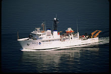
One of the tasks that needs to be done prior to the deployment of our first Buoy at 8N:155W is to determine (as close as possible) the ideal position for the buoy’s anchor. To do this it is essential to know the true depth of the ocean and the topography (collectively called bathymetry) of the area within a few miles of the target latitude and longitude for the buoy. Brian, our Chief Scientist, will determine the depth and location for the anchor by using both satellite sea surface heights and actual sonar depth data from ships that have been in the area. In reality, there really isn’t much
 hard data, physical sonar tracks, for much of the ocean and much of the depth is determined by the actually height of the sea surface as measured by satellite. These measurements take into account variables, such as orbit of the satellite, atmospheric effects on radar, and tides and compare the computer result to a mathematical ellipsoid model of the Earth’s shape. Sounds pretty complicated, and it is, but we can use this calculated sea surface to help determine the depth of the ocean since the surface mirrors the actual topography of the ocean floor. For Academy students, you will have the opportunity to do two activities from the American Meteorological Society (AMS) that will help you understand what it is that we are attempting to do.

One last comment from Rick, my school has a set of four computer monitors in the hall outside of my classroom thanks to Mr. Beals. The Earth Science department puts up content relevant sites for the kids to see as they pass from room to room. Typically we would have the weather (which I hear has been bitter) some current earthquake data from our own seismograph and other content sites that relate to the current teaching units. Thank you Senior High Academy for giving me the opportunity to be on the screen in the hall.
Rick
No comments:
Post a Comment